- Objectives
(a) To replicate natural conditions of infiltration, evapotranspiration, and runoff. In typical natural conditions, approximately 50 percent of stormwater infiltrates, 40 percent leaves land through evapotranspiration, and ten (10) percent leaves the land as runoff.(b) To promote decentralized stormwater management systems modeled after natural hydrologic features and infiltration practices that facilitate local groundwater recharge [Low-Impact Development (“LID”) techniques]. (c) To promote water conservation and efficiency through stormwater capture, treatment and reuse. - General Provisions.
(a) The stormwater design standards and criteria shall apply to all projects under DEC review. (b) All Applications, regardless of whether the project is subject to the Wetlands Protection Act or not, shall design the stormwater management system in compliance with the Massachusetts DEP Stormwater Management Standards, January, 2008, as amended (“SMS”) and the Massachusetts Stormwater Handbook, February 2008, as amended (“Handbook”). The Applicant shall submit a completed and endorsed Stormwater Management Form that indicates compliance with the SMS, in addition to any supporting calculations indicating compliance with the required standards. http://www.mass.gov/dep/water/laws/policies.htm#storm. (c) Stormwater management systems shall comply with the following: - The Handbook which includes the SMS, Stormwater Best Management Practices, Documenting Compliance, Stormwater Report Checklist and TSS Removal Calculation Sheet.
- Devens Stormwater Pollution Prevention Plan (Stormwater Plan).
- Devens Water Resources Protection Report.
- The Design Standards and Criteria outlined in §4.08(3).
(d) Where there is a conflict between the requirements set forth below and the Handbook and/or Plan, the Plan and the requirements below shall govern. - There shall be no negative impact from stormwater runoff on abutting properties and to any public or private water supply or designated potential future supply.
- Irrigation water shall be derived from detained treated stormwater (stormwater harvesting), or roof drainage to the maximum extent feasible. On-site cisterns may be installed to store water for irrigation.
- For all stormwater improvements, drainage calculations shall be prepared by the Applicant's Engineer in accordance with the SMS requirements and shall include design criteria, pre- and post-development drainage areas, and other information to verify the size and effectiveness of the proposed stormwater management technique. "Pre-development" drainage areas shall be considered to be "green fields" regardless of any development or improvements on the site at the time of application. Calculations shall be made separately for each drainage facility, showing its location, the total upstream drainage area, the underlying soil types and the flow paths for the times of concentration, the design runoff, facility size, slope, and capacity and velocity of water through all the site drainage system.
- Proposed activity that will temporarily or permanently disturb any land area at or below the elevation of the 100-year floodplain shall be avoided to the maximum extent feasible unless there are exceptional circumstances where such areas cannot be avoided. Under such circumstances, the Applicant shall demonstrate, to the satisfaction of the DEC, that there shall be no temporary or permanent loss of flood storage area. For any areas within the 100-year floodplain where the DEC authorizes disturbance, temporary stabilization measures shall be implemented at all times, until permanent stabilization is achieved. No construction laydown areas or equipment shall be stored within the 100-year floodplain without emergency removal/relocation measures in place and approved by the DEC.
- Recharge may not be required for land designated as an Area of Concern, if, according to the Base Closure Team in accordance with Base Realignment and Closure Act requirements, recharge will negatively impact ongoing environmental remediation.
- All projects, including flood management and culvert replacement projects, shall incorporate LID techniques for stormwater management to the maximum extent feasible. For projects proposing traditional closed drainage systems, the Applicant shall demonstrate to the satisfaction of the DEC why LID stormwater management design methods are not feasible. For LID stormwater controls not referenced in this section (974 CMR 4.08) or the Handbook, or for which pollutant removal rates have not been provided, the effectiveness and pollutant removal of the structural control must be documented through prior studies, literature reviews, or other means and receive approval from the DEC before being included in the design of a stormwater management system.
- In addition to LID controls outlined in this section (974 CMR 4.08) or the Handbook, flood management and culvert replacement projects shall assess, and to the maximum extent feasible implement, stream daylighting1 and improved channel connectivity2.
______________
1 “Stream daylighting” means the practice of exposing some or all of a previously buried river, stream, and/or stormwater drainage and restoring the watercourse to a more natural condition.
2 “Channel connectivity” means the degree to which hydrologic components of a river system or watershed are joined, or connected, by various transport mechanisms including streams, non-tidal wetlands, riparian buffers, or underground aquifers.
- Design standards and criteria: All stormwater management systems shall meet the following:
(a) Biofiltration basins shall be the preferred method to reduce curbing, piping and structures and provide additional overland treatment and recharge. They shall be designed in accordance with the Handbook, in addition to the following:1. Any low-flow outlets shall be designed to prevent clogging.2. For bioretention cells, abutting pavement, that are designed to capture sheet flow, the edge of pavement shall be reinforced to ensure the integrity of pavement is maintained (curb stops, stone, turf, landscape timbers, plantings or other acceptable methods or combination thereof.) (b) All projects shall manage all stormwater onsite, unless granted an exemption by the DEC that this requirement is not feasible.
i. If a project is granted an exemption under §4.08(3)(b), all stormwater runoff from the site must satisfy the requirements of 974 CMR 3.04(4)(b) before being discharged to the Devens Municipal Separate Storm Sewer System (MS4).
ii. If a project is granted an exemption in accordance with §4.08(3)(b)(i), the developer of the project shall propose a Mitigation Project to be implemented as a component of project approval, and the DEC will publicize the project’s annual Total Suspended Solids (TSS) removal worksheets on the DEC’s website. A “mitigation project” shall mean an infrastructure project designed to mitigate adverse water quality impacts from a previously completed project, or from an area which has no stormwater treatment and management facilities, by improving the quality of stormwater runoff onsite or at an off-site location.
(c) In addition to compliance with the SMS, the post-development peak rate of stormwater discharge off-site shall not be greater than the pre-development peak rate of stormwater discharge for the 2, 10, 25, 50 and 100-year storm events from any point of discharge on the site. In accordance with Section 2.d.iii. above, pre-development peak rate calculations shall reflect the “green field” site condition, regardless of any existing development or impervious coverage on the site at the time of application. (d) There shall be no stormwater structures and/or point source discharges within 25 feet of the boundaries of any Resource Area unless the Applicant can demonstrate no adverse impact to the Resource Area. (e) Side slopes above the design water level shall be 3:1 (horizontal to vertical) or flatter and conform to the slope of the existing topography without abrupt or unnatural breaks in slope, unless otherwise permitted under 974 CMR 4.08(4). (f) Banks of wet ponds, swales not within maintained landscaped areas (such as lawns or parking lots), and other channels shall be vegetated with native woody plant material within ten feet of the high water elevation and with herbaceous plant material at the edge of the pond at the high water elevation. Trees shall not be planted on fill embankments. (g) Shelves below the design water level (as described in the Stormwater Plan) shall be vegetated with hydrophytic native plant species at a density needed to establish full coverage by the next growing season. Plant plugs or pre-vegetated coir-mesh blankets or carpets are recommended materials. (h) Recommended post-construction erosion control methods include geotextile and /or biodegradable erosion control fabrics staked or anchored to the slope, with loose weave to allow vegetative cover to be established. Vegetative cover shall consist of native woody plant species installed as live brush or nursery stock, or native grasses.
(i) Stormwater management systems shall be designed to meet an average annual pollutant removal equivalent to 90% of the average annual load of Total Suspended Solids (TSS) related to the total post-construction impervious area on the site AND 60% of the average annual load of Total Phosphorus (TP) related to the total post-construction area on the site3.
i. Average annual pollutant removal requirements in §4.08(3)(h) are achieved through one of the following methods:
• Installing BMPs that meet the pollutant removal percentages developed consistent with EPA Region 1’s BMP Accounting and Tracking Tool (2016) or other BMP performance evaluation tool provided by EPA Region 1, where available. If EPA Region 1 tools do not address the planned or installed BMP performance, then any federally or State-approved design guidance or performance standards (e.g. the Handbook) may be used to calculate BMP Performance; or
• Retaining the volume of runoff equivalent to, or greater than, one (1.0) inch multiplied by the total post-construction impervious surface on the development site, or
• Meeting a combination of retention and treatment that achieves the above standards; or
• Utilizing offsite mitigation in accordance with §4.08(3)(b) that meets the above standards within the same USGS HUC12 as the development site.
ii. Maintenance and redevelopment activities related to existing roads including repaving, drainage infrastructure improvements, adding shoulder, or correcting intersections shall be exempt from other requirements in this part. Projects of this nature should consider options to improve any existing conditions by incorporating LID techniques or other stormwater best management practices and include in the construction permit application process a narrative describing that investigation’s conclusions and chosen results when possible. Any road construction that increases the impervious surface by more than a single land width will not be covered under this exemption and shall be subject to all requirements in §4.08.3.(h).
(j) To support compliance with the MS4 Permit, all BMPs must be optimized for the removal of phosphorus. The justification and design of such BMPs must also include a methodology for assessing BMP performance. Pollutant removal shall be consistent with EPA Region 1’s evaluation tool.
______________
3 Pollutant removal is calculated based on average annual loading and not on the basis of any individual storm event.
- Design standards and criteria for detention/retention/recharge basins: The design of stormwater and infiltration basins and associated structures shall:
(a) Minimize basin size to 5,000 square feet per basin or less (by using smaller catchment areas and/or alternative stormwater management design methods) and minimize disturbance to natural or re-established vegetated areas to the maximum extent feasible. If a basin exceeds 5,000 square feet, the Applicant shall demonstrate to the satisfaction of the DEC why a smaller size is not feasible. If a basin is a constructed stormwater wetland, it may exceed 5,000 square feet upon approval by the DEC. Constructed stormwater wetlands shall be designed in compliance with the SMS. (b) Be located in naturally occurring low spots. Layout of the basins shall complement the natural topographic movement of the site [see 974 CMR 3.08(4) Figure D)] Rigid basin layout [see 974 CMR 3.08(5) Figure E] shall be avoided in all instances unless the basin's layout complements the overall design concept of the Site Plan. (c) Utilize banks steeper than 3:1 (horizontal to vertical) only to tie into headwall/outfall structures. Banks steeper than 3:1 shall transition to slopes of less than 3:1 as quickly as possible to minimize areas of potential erosion. Specific post-construction erosion control methods shall be detailed to ensure temporary and permanent stabilization of such areas will be achieved. Rip-rap/trap rock solutions shall not be acceptable, except as water dissipaters below storm water outfalls or as channel liners for steep swales. (d) Have an emergency outlet to accommodate storm flows in excess of the 100-year storm event. A minimum 1-foot freeboard distance shall be established between the 100-year flood elevation and the top of embankment. (e) Design basins/infiltration structures using the Natural Resource Conservation Service TR-20 methodology in accordance with the SMS. (f) Locate the floor of all basins/infiltration structure/swales a minimum of four feet above the high groundwater elevation. High groundwater testing shall be conducted before the basin design at the proposed location of each basin in compliance with Title V (310 CMR Section 15.103), as most recently amended or reliable data pursuant thereto shall be provided. (g) Conduct a falling head soil permeability test in retention/infiltration basins before the basin design in all basins and infiltration structures. Soil with a percolation rate of 2 minutes per inch or faster can be used to confirm the first NRCS Hydrologic Soil Group A with a Texture Class of Sand and an infiltration rate of 8.27 Inches per hour from the Rawls, et.al. table in the SMS. To use infiltration rates faster than 8.27 inches per hour, use 50% of the infiltration rate obtained from the falling head soil permeability test. (h) Conduct percolation tests in detention basins before the basin design and shall be conducted in compliance with Title V (310 CMR Section 15.105), as most recently amended. (i) Include fencing and/or screening of stormwater detention/retention basins if the DEC determines that safety or appearance require such measures. - Design Standards and Criteria for Certain Structural LID Techniques:
(a) Vegetated Roofs - shall comply with the Handbook and the DEC Policy for Construction of Vegetated Roofs dated August 2011, as amended.- For the purposes of stormwater management system design, the area of roof covered by vegetation may be considered pervious and subtracted from the total proposed impervious area.
- Vegetated Roofs within the Viewshed Overlay district shall comply with 974 CMR 3.04(8) (i) 5 and 6.
- Landscaping plans for projects incorporating vegetated roofs and/or walls shall show the design and location of vegetated roofs and walls.
(b) Permeable paving [Porous asphalt, paving stones and pervious concrete] - May be used where the underlying soils have a permeability of at least 0.3” per hour but shall not be used on high-traffic/high speed areas or on stormwater “hotspots” with high pollutant loads. Permeable paving shall meet the SMS specifications (or alternatives approved by the DEC), in addition to the following: - Lined on the sides with a non-woven geotextile fabric to prevent influx of fines (no liner on bottom).
- A gravel trench surrounding the edge of the pavement connecting to the stone reservoir below the surface of the pavement may be required as a backup in the event of surface clogs.
- Installed by a qualified contractor with experience in permeable paving installation.
- Specification layer depths required by the SMS may be increased based on volume storage requirements
(c) Additional Requirements for Pervious concrete – 1. Top layer: 6 inches of pervious concrete placed in two 3-inch courses.
2. Second layer: 4 inch course consisting of 1-1/3 inch crushed stone (structural support).
3. Third layer: 14 inches of open graded “bank run gravel” (Reservoir base).
4. Fourth layer: 6 inches of 3/8” crushed gravel (Capillary barrier).
(d) Reinforced Turf Parking/Emergency Access - May be constructed where the underlying soils have a permeability of at least 0.3” per hour but shall not be used on high-traffic/high-speed area or on stormwater “hotspots” with high pollutant loads. Turf parking shall be designed to meet the SMS and the following specifications:
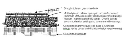
Alternative comparable reinforcement methods will be considered by the DEC on a case by case basis.
- Closed Drainage Systems.
(a) LID swale systems shall be utilized in parking lots not subject to truck traffic, truck and container storage, and other railroad related vehicles/equipment, to the maximum extent feasible.(b) Closed Drainage Systems (CDS) and swales shall be designed to accommodate the 25-year storm event based on the Rational Method without surcharging. The CDS shall be designed in accordance with the SMS. Intensity/duration/frequency curves for the Worcester area, as presented in Technical Paper 40 of the National Weather Service and the Massachusetts Hydrology Handbook for Conservation Commissioners, March 2002, as amended, shall be used in the drainage design calculations. The minimum time of concentration shall be five minutes. 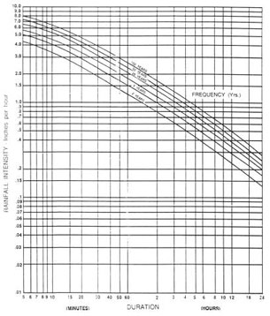
Intensity – Duration – Frequency Curve for Worcester, MA
(c) All drainage structures shall be constructed of pre-cast concrete. (d) Catch basins shall have oil traps and provide a four-foot sump. (e) Details for all drainage structures shall be provided. (f) Flow capacities shall be calculated, using two feet per second (fps) minimum velocity and 10 fps maximum velocity under a 2-to-25 year design storm event. The designer shall account for partial pipe flow capacities, if applicable to the design. (g) Catch basin to catch basin connections are prohibited in paved areas. (h) Sub-surface infiltration systems are considered closed drainage systems and shall at a minimum meet an 80% TSS removal rate prior to infiltration to reduce maintenance and potential for system failure and replacement - Monitoring and Maintenance of Stormwater Facilities. An Operation and Maintenance Plan (O&M Plan) for stormwater management systems is required at the time of application for all projects. The O&M Plan shall be designed to ensure compliance with the Massachusetts Surface Water Quality Standards (314 CMR 4.00), the Stormwater Plan and the DEC annual stormwater reporting form requirements. The O&M Plan shall be shown on the site plan(s) and shall include at a minimum the following:
(a) The name(s) of the owner(s) for all components of the system.
(b) A statement that the Applicant is responsible for the operation and maintenance of the entire on-site system, including emergency repairs.
(c) If applicable, a statement providing stormwater management easements to the DEC as necessary for access for facility inspections and maintenance, and preservation of stormwater runoff conveyance, infiltration, and detention areas and facilities, including flood routes for the 100-year storm event. The purpose of each easement shall be specified in the maintenance agreement signed by the property owner.
(d) An O&M Inspection and Maintenance Schedule which shall include:
- Parking Lot Sweeping: with mechanized cleaning equipment on an annual basis.
- Catch Basin Cleaning: Catch Basins and Infiltration Chambers shall be inspected on a bi-annual basis. Any sediment accumulations in excess of half of the unit’s sump depth shall be removed. Material shall be removed by a licensed contractor, who shall be responsible for disposing of the material off-site in a manner consistent with all local, state and federal regulations.
- Infiltration Swales: Ensure proper establishment of full vegetative cover. Swale embankments and side slopes must be properly maintained to ensure long-term stability. Annual and seasonal inspections are required to ensure a healthy groundcover is maintained to avoid erosion and promote infiltration. Bare spots shall be repaired and planted with native ground cover material. Saplings and large shrubs shall be removed to maintain integrity of the swale. Level spreader shall be inspected seasonally to remove any build up of sediment and ensure proper drainage flows.
- Detention/Retention Basin Inspection and Maintenance: Wet and dry basins shall be inspected annually to ensure inlets and outlets remain unobstructed. Inlets and outlets and forebays shall also be inspected for potential sediment, erosion, cracking, tree growth, damage to the emergency spillway and erosion within the basin and on within the banks. Upper side slopes, embankment and emergency spillway shall be mowed annually. Any tree saplings shall be removed. Accumulated sediment shall be removed as necessary and at least once every ten years. Bare spots shall be repaired and planted with native ground cover material.
- Biofiltration Systems: Quarterly inspections for accumulated sediment shall be performed. Debris, sediment accumulation, erosion shall be removed/repaired at least twice a year. Any dead or damaged plantings shall be replaced. All invasive species shall be removed on an annual basis. Re-mulch any void areas by hand. Native grasses and plants shall be maintained by hand without the use of fertilizers and limited use of organic herbicides. Trimming of surrounding grasses shall be restricted to a minimum of 5 inches. When cation exchange capacity of soil media decreases, the soil media shall be replaced to prevent contaminants from reaching the groundwater.
- Sediment Trap/Oil-Water Separator: Shall be inspected annually for sediment and debris accumulation. Any sediment accumulations in excess of half of the unit’s sump depth shall be removed. Material shall be removed by a licensed contractor, who shall be responsible for disposing of the material off-site in a manner consistent with all regulations.
- Sub-Surface Infiltration Systems: Shall be inspected annually for proper function and sediment accumulation. Accumulations of sediment and/or materials that negatively impact the infiltration capacity of the system shall be removed.
- Constructed Stormwater Wetlands: In the first three years after construction, Applicants shall inspect the constructed stormwater wetlands twice a year during both the growing and non-growing seasons. After three years such inspections shall occur on a periodic basis. During these inspections, the following information shall be recorded:
a. The types and distribution of the dominant wetland plants in the marsh;
b. The presence and distribution of planted wetland species;
c. The presence and distribution of invasive wetland species (invasives shall be removed);
d. Indications that other species are replacing the planted wetland species;
e. Percentage of standing water that is unvegetated (excluding the deep water cells which are not suitable for emergent plant growth);
f. The maximum elevation and the vegetative condition in this zone, if the design elevation of the normal pool is being maintained for wetlands with extended zones;
g. Stability of the original depth zones and the micro-topographic features; and
h. Accumulation of sediment in the forebay and micropool; and survival rate of plants (cells with dead plants must be replanted). Sediment forebays must be cleaned annually.
(e) Applicants shall submit annual stormwater monitoring and maintenance reports to the DEC addressing inspection and maintenance of the BMPs. The reports shall include:
1. Descriptions of the condition of the BMPs,
2. Descriptions of maintenance performed and,
3. Receipts for maintenance performed.
For ease of reporting, the DEC and MassDevelopment have created standard annual reporting templates for use by all Applicants. Failure to submit the required annual report is a violation of the Unified Permit.
(f) The O&M Plan must be signed by the owner and must include a provision that the transfer of responsibilities is understood by future owners.
|