DEC logoRULES AND REGULATIONS
Regulatory Authority: Devens Enterprise Commission
Agency Contact: Peter C. Lowitt
Phone: 978.772.8831 ext 3338
Address: 33 Andrews Parkway, Devens, MA 01434
Massachusetts Register Number 881
Effective Date: November 2013

974 CMR 3.00 SITE PLAN

3.06 Steep Slope Protection

  1. Purpose. Development on or adjacent to unique ridgelines, slopes and plateaus can have an adverse impact on:

      (a) Water quality by causing erosion and sedimentation and changing patterns of stormwater runoff;

      (b) Wildlife habitat and corridors; and

      (c) Slope stability.

    These adverse impacts can be avoided by restricting development and mitigating its impacts.

  2. Applicability. The General Requirements of this subsection 974 CMR 3.06 apply to Slope Resource Areas (SRAs) shown on the Devens Slope Resource Area Map [see Appendix B Figures (13) Figure M and SRA buffer areas (as described below)] and development outside these areas that may impact them.

  3. General Requirements

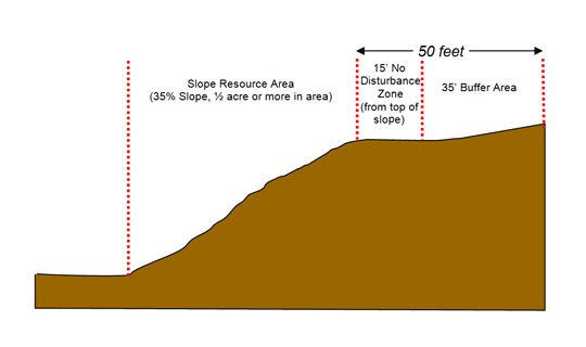
      (a) There shall be no Site Disturbance in SRAs and the 15' No Disturbance Area around them, except that the following are permitted:

        1. Construction of low-impact hiking/walking trails identified in the 2001 Devens Main Post Trails Plan;

        2. Removal of the minimum number of trees necessary to ensure adequate site lines but in no instance shall roots be removed unless the DEC approves a vegetation and soil management plan designed to maintain slope and soil stability; and

        3. Removal of vegetation and re-planting of native plant species may be allowed according to a vegetation and soil management plan approved by the DEC if the area has been previously disturbed by recent human activity or is infested by noxious weeds and/or invasive plant species.

      (b) There shall be no Site Disturbance within the 35' Buffer Area beyond the 15' No Disturbance Area, unless the DEC makes a finding that the proposed activity will have no adverse impacts on the structure and stability of the SRA and 15' No Disturbance Area. To support such a Finding, the Applicant shall be required to submit a geotechnical report, prepared by a professional geotechnical engineer, that demonstrates the proposed activity within the 35' Buffer will have no adverse impacts on the structure and stability of the SRA. Any development authorized within the 35' Buffer Area shall preserve existing vegetation to the maximum extent feasible.

      (c) The Applicant shall demonstrate to the satisfaction of the DEC that (i) additional stormwater runoff from the proposed development is not directed toward the SRA or SRA Buffer Areas and that (ii) there are adequate measures in place to ensure there is no increase in the rate of stormwater runoff directed toward the SRA or SRA Buffer Areas.

  4. Definitions.

    The following definitions pertain to this subsection 974 CMR 3.06 only:

    Site Disturbance: Any activity which removes the vegetative cover and/or soils from the land surface.

    Slope Resource Area (SRAs): Naturally formed, undisturbed slopes with a contiguous areas of a ½ acre or more. These areas are identified on the Devens Slope Resource Area Map in 974 CMR 3.06 Appendix B Figures (13) Figure M. Such slopes are generally in excess of 35%, with mature vegetative cover and in close proximity to sensitive resource areas and/or unique geological formations.
    Slope Resource Area graph


Rules and Regulations Table of Contents    Home     Search   Next Section   Previous Section